To Know Where the Birds Are Going, Researchers Turn to Citizen Science and Machine Learning
Computer scientists at the University of Massachusetts Amherst, in collaboration with biologists at the Cornell Lab of Ornithology, recently announced in the journal Methods in Ecology and Evolution a new, predictive model that is capable of accurately forecasting where a migratory bird will go next—one of the most difficult tasks in biology. The model is called BirdFlow, and while it is still being perfected, it should be available to scientists within the year and will eventually make its way to the general public.
“Humans have been trying to figure out bird migration for a really long time,” says Dan Sheldon, professor of information and computer sciences at UMass Amherst, the paper’s senior author and a passionate amateur birder. “But,” adds Miguel Fuentes, the paper’s lead author and graduate student in computer science at UMass Amherst, “it’s incredibly difficult to get precise, real-time information on which birds are where, let alone where, exactly, they are going.”
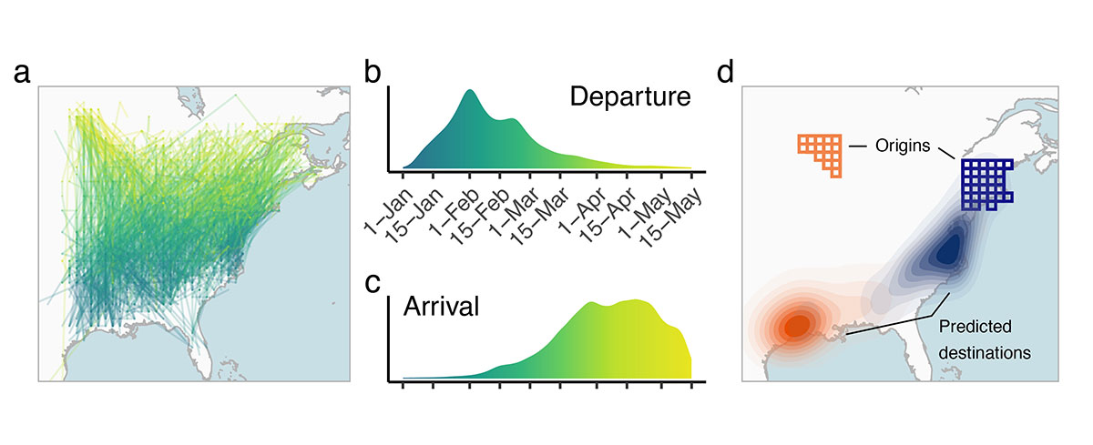
Derived model outputs for American Woodcock: (a) Simulated spring migration trajectories. (b) Timing of spring migration departure and (c) arrival derived from simulated trajectories. (d) Migratory connectivity: square cells show breeding origins of individuals in the northwest (orange) and northeast (blue) parts of the breeding range. Filled density contours show the predicted wintering distributions of individuals breeding in those respective regions. Credit Fuentes et al., 10.1111/2041-210X.14052
There have been many efforts, both previous and ongoing, to tag and track individual birds, which have yielded invaluable insights. But it’s difficult to physically tag birds in large enough numbers—not to mention the expense of such an undertaking—to form a complete enough picture to predict bird movements. “It’s really hard to understand how an entire species moves across the continent with tracking approaches,” says Sheldon, “because they tell you the routes that some birds caught in specific locations followed, but not how birds in completely different locations might move.”
In recent years, there’s been an explosion in the number of citizen scientists who monitor and report sightings of migratory birds. Birders around the world contribute more than 200 million annual bird sightings through eBird, a project managed by the Cornell Lab of Ornithology and international partners. It’s one of the largest biodiversity-related science projects in existence and has hundreds of thousands of users, facilitating state-of-the-art species distribution modeling through the Lab’s eBird Status & Trends project. “eBird data is amazing because it shows where birds of a given species are every week across their entire range,” says Sheldon, “but it doesn’t track individuals, so we need to infer what routes individual birds follow to best explain the species-level patterns.”
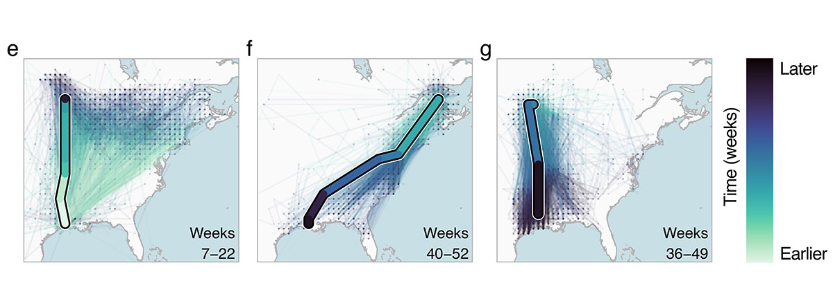
Observed movements of GPS-tracked woodcocks (single thick path) and simulated trajectories (thin paths) for 2500 simulated birds originating at the same starting location as observed birds. Credit: Fuentes et al., 10.1111/2041-210X.14052
BirdFlow draws on eBird’s Status & Trends database and its estimates of relative bird abundance and then runs that information through a probabilistic machine-learning model. This model is tuned with real-time GPS and satellite tracking data so that it can “learn” to predict where individual birds will move next as they migrate.
The researchers tested BirdFlow on 11 species of North American birds—including the American Woodcock, Wood Thrush and Swainson’s Hawk—and found that not only did BirdFlow outperform other models for tracking bird migration, it can accurately predict migration flows without the real-time GPS and satellite tracking data, which makes BirdFlow a valuable tool for tracking species that may literally fly under the radar.
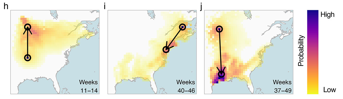
Each heatmap shows the predicted movement distribution of a GPS-tracked individual originating within the circle at the base of the arrow. Darker colors indicate a higher predicted likelihood of movement to that area. The point of the arrow shows the observed ending location. Shown are examples of 3-week (h), 6-week (i), and 12-week (j) conditional forecasts. Credit: Fuentes et al., 10.1111/2041-210X.14052
“Birds today are experiencing rapid environmental change, and many species are declining,” says Benjamin Van Doren, a postdoctoral fellow at the Cornell Lab of Ornithology and a co-author of the study. “Using BirdFlow, we can unite different data sources and paint a more complete picture of bird movements,” Van Doren adds, “with exciting applications for guiding conservation action.”
With an $827,000 grant from the National Science Foundation, Sheldon and his colleagues are improving BirdFlow and plan to release a software package for ecologists to use later this year, with future development aimed at visualization products geared towards the general public.
This story was originally published by the Office of News and Media Relations.